


DC Metro Transit - Free
Descripción de DC Metro Transit - Free
DC Metro Transit (Free) is an ad-supported mobile interface for WMATA (Metro and Bus) and other local agencies. A paid, ad-free, version is also available.
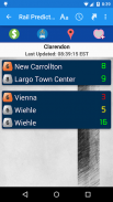
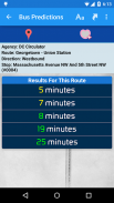
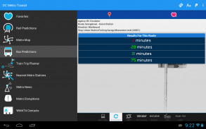
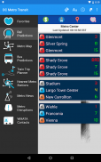
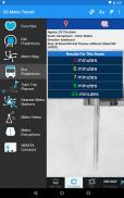
Get real-time predictions for DC Metrorail, Metro Bus, Arlington Transit (ART), DC Circulator, PG County - The Bus, Fairfax CUE, GMU Shuttle, and UMD Shuttle. Keep track of your favorite stations and sort them however you like!
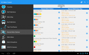
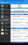
Find your way to the nearest Metrorail stations and WMATA bus stops by using your devices GPS with the “Nearest Stations” feature. Once you have your results, one click will get you turn by turn directions with Google Maps.
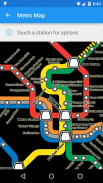
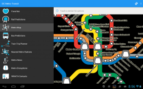
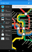
Use our interactive map of the Metrorail system to find your way around. Having trouble finding a station entrance?
Click a station on the map and choose “Street View” and have a look around.
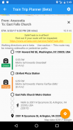
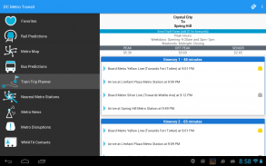
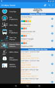
The train trip planner will help you to plan your station-to-station trip, help you with transfers, and provide time, distance, and fare estimates for your trip.
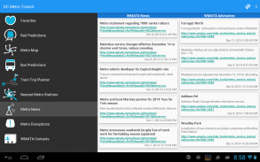
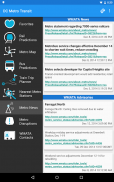
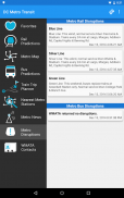
Keep up to date with the latest News, Advisories, and system outages that may impact your commute.
**If you run into issues, please email the support email address. The support email is monitored daily and is the fastest way to get a resolution!**DC Metro Transit (gratuito) es una interfaz móvil con publicidad para WMATA (metro y autobús) y otras agencias locales. Un pago, sin publicidad, la versión también está disponible.
Recibe las predicciones en tiempo real para DC Metrorail, Metro Bus, Arlington Transit (ART), CC de circulación, Condado de PG - El Bus, Fairfax CUE, GMU traslado y traslado UMD. Lleve un registro de sus estaciones favoritas y ordenarlas a tu gusto!
Encuentra tu camino a las estaciones de Metrorail más cercanas y autobuses WMATA detiene utilizando dispositivos GPS con la función "Estaciones más cercanos". Una vez que tenga los resultados, un clic te llevará instrucciones paso a paso con Google Maps.
Utilice nuestro mapa interactivo del sistema de Metrorail para encontrar su camino alrededor. ¿Tiene problemas para encontrar una entrada de la estación?
Haga clic en una estación en el mapa y elegir la opción "Street View" y echar un vistazo alrededor.
El planificador de viajes en tren le ayudará a planificar su viaje de estación a estación, ayuda con las transferencias, y proporciona el tiempo, la distancia, y las estimaciones de tarifas para su viaje.
Manténgase al día con las últimas noticias, avisos, y las interrupciones del sistema que pueden afectar su viaje.
** Si se encuentra con problemas, por favor escriba la dirección de correo electrónico de apoyo. El correo electrónico de apoyo es revisado diariamente y es la manera más rápida para obtener una resolución! **
DC Metro Transit - Free - Versión 5.12.10
(02-05-2021)DC Metro Transit - Free - Información de APK
Version de la app: 5.12.10Paquete: com.jazzmoonstewdio.android.dcmetro.activityÚltima versión de DC Metro Transit - Free
Otras versiones


Apps en la misma categoría

Quizá también te interese...


